Anomalously High Heat Flow Regions Beneath the Transantarctic Mountains and Wilkes Subglacial Basin in East Antarctica Inferred From Curie Depth

Jan 1, 2023·
Maximilian Lowe
Maximilian Lowe
Dr. Ben Mather
Dr. Ben Mather
Chris Green
Chris Green
Tom A. Jordan
Tom A. Jordan
Jörg Ebbing
Jörg Ebbing
Robert Larter
Robert Larter
· 1 min read
Abstract
The Transantarctic Mountains (TAMs) separate the warmer lithosphere of the Cretaceous-Tertiary West Antarctic rift system and the colder and older provinces of East Antarctica. Low velocity zones beneath the TAM imaged in recent seismological studies have been interpreted as warm low-density mantle material, suggesting a strong contribution of thermal support to the uplift of the TAM. We present new Curie Point Depth (CPD) and geothermal heat flow (GHF) maps of the northern TAM and adjacent Wilkes Subglacial Basin (WSB) based exclusively on high resolution magnetic airborne measurements. We find shallow CPD and high GHF beneath the northern TAM, reinforcing the hypothesis of thermal support of the topography of the mountain range. Additionally, this study demonstrates, that limiting spectral analysis to areas with a high density of aeromagnetic measurements increases the resolution of CPD estimates revealing localized shallow CPD and associated high heat flow in the Central Basin of the WSB and the Rennick Graben (RG). Across the study area the CPD ranges from 15 to 35 km and the GHF values range from 30 to 110 mW/m2. The recovered CPD range is compatible with recent Moho depth estimates, as the CPD predominantly lies within the crust, rather than in the magnetite-poor mantle. GHF estimates, based on the CPD estimates, show a good agreement to sparse in situ GHF measurements and the location of active volcanoes. Comparison to existing continent-wide GHF estimates shows strong differences from magnetically-derived heat flow estimates, while seismologically-derived heat flow estimates show the best agreement to our results.
Type
Publication
Journal of Geophysical Research: Solid Earth
publications

Plain Language Summary

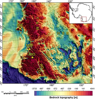
The Transantarctic Mountains are one of the longest mountain ranges on Earth, separating the geologically younger West Antarctica from the ancient East Antarctic craton. Scientists have long debated what holds these mountains up — whether it is the buoyancy of thick crustal roots or heat rising from deeper in the Earth. This study uses magnetic data collected from aircraft to estimate the Curie depth — the depth at which rocks become too hot for magnetic minerals to retain their magnetism — as a proxy for underground temperatures.

The results reveal unusually shallow Curie depths and high heat flow beneath the northern Transantarctic Mountains, supporting the idea that warm mantle material is helping to prop up the mountain range from below. The study also finds pockets of elevated heat flow in the adjacent Wilkes Subglacial Basin and the Rennick Graben, regions hidden beneath the Antarctic ice sheet.

These heat flow estimates are important for understanding ice sheet dynamics, since basal heat flow influences whether the bottom of the ice sheet melts and how ice flows. The findings provide new constraints on the thermal state of East Antarctica, which remains one of the least explored continents on Earth.

Maximilian Lowe
Authors
Postdoctoral Researcher
Maximilian Lowe uses airborne and satellite gravity and magnetic data to investigate crustal and lithospheric structure and heat flow beneath the Antarctic ice sheet.
Dr. Ben Mather
Authors
ARC Industry Research Fellow

I am an ARC Industry Research Fellow in the School of Geography, Earth and Atmospheric Sciences at The University of Melbourne. I am an expert in fusing Earth evolution models with data to understand how groundwater moves critical minerals through the landscape. Related research interests include the cycling of volatiles within the Earth, probabilistic thermal models of the lithosphere to unravel past tectonic and climatic events, and understanding the how enigmatic volcanoes form.

I am a vocal advocate for the integral role of geoscience in responding to challenges we face in transitioning to the carbon-neutral economy. As an expert in my field, I have been interviewed in national and international print media, TV, and radio on a wide variety of subjects including earthquakes, volcanoes, groundwater, and critical minerals.

Chris Green
Authors
Geophysical Consultant
Chris Green has over 30 years of experience in the processing and interpretation of gravity and magnetic data for geological applications.
Tom A. Jordan
Authors
Aerogeophysicist
Tom Jordan collects, processes, and interprets airborne magnetic, gravity, and radar data to investigate the geological and tectonic evolution of Antarctica.
Jörg Ebbing
Authors
Professor of Satellite and Aerogeophysics
Jörg Ebbing studies the structure of the lithosphere through combined interpretation of satellite and terrestrial potential field data, with emphasis on solid Earth-cryosphere interactions.
Robert Larter
Authors
Marine Geophysicist
Robert Larter specialises in Antarctic marine geophysics, Quaternary ice sheet history, and glacial geomorphology.