Deep time spatio-temporal data analysis using pyGPlates with PlateTectonicTools and GPlately
Plain Language Summary
Reconstructing how the Earth’s tectonic plates have moved over hundreds of millions of years is essential for understanding everything from past climates to the distribution of natural resources. GPlately is an open-source Python package that makes it easier for researchers to work with plate tectonic reconstructions by providing a streamlined interface built on top of pyGPlates — the Python library for the GPlates plate reconstruction software.
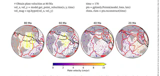
With GPlately, scientists can reconstruct the past positions of continents, ocean basins, and geological features through deep time. The package can calculate plate velocities, rates of subduction and seafloor spreading, and allows rapid comparison between different plate motion models. Results can be plotted on maps to visualize how the Earth’s surface has changed over billions of years.
All of GPlately’s tools are designed to run efficiently on multiple processors, making it practical to analyse large datasets that span vast stretches of geological time. The package is freely available and is intended to lower the barrier for researchers who want to integrate plate tectonic reconstructions into their scientific workflows.