Deep time spatio-temporal data analysis using pyGPlates with PlateTectonicTools and GPlately

Apr 5, 2023·
Dr. Ben Mather
Dr. Ben Mather
R. Dietmar Müller
R. Dietmar Müller
Sabin Zahirovic
Sabin Zahirovic
,
John Cannon
,
Michael Chin
Lauren Ilano
Lauren Ilano
Nicky M. Wright
Nicky M. Wright
Christopher P. Alfonso
Simon Williams
Simon Williams
Michael Tetley
Michael Tetley
Andrew S. Merdith
Andrew S. Merdith
· 1 min read
Abstract
PyGPlates is an open-source Python library to visualize and edit plate tectonic reconstructions created using GPlates. The Python API affords a greater level of flexibility than GPlates to interrogate plate reconstructions and integrate with other Python workflows. GPlately was created to accelerate spatio-temporal data analysis leveraging pyGPlates and PlateTectonicTools within a simplified Python interface. This object-oriented package enables the reconstruction of data through deep geologic time (points, lines, polygons and rasters), the interrogation of plate kinematic information (plate velocities, rates of subduction and seafloor spreading), the rapid comparison between multiple plate motion models, and the plotting of reconstructed output data on maps. All tools are designed to be parallel-safe to accelerate spatio-temporal analysis over multiple CPU processors.
Type
Publication
Geoscience Data Journal
publications

Plain Language Summary

Reconstructing how the Earth’s tectonic plates have moved over hundreds of millions of years is essential for understanding everything from past climates to the distribution of natural resources. GPlately is an open-source Python package that makes it easier for researchers to work with plate tectonic reconstructions by providing a streamlined interface built on top of pyGPlates — the Python library for the GPlates plate reconstruction software.

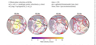
With GPlately, scientists can reconstruct the past positions of continents, ocean basins, and geological features through deep time. The package can calculate plate velocities, rates of subduction and seafloor spreading, and allows rapid comparison between different plate motion models. Results can be plotted on maps to visualize how the Earth’s surface has changed over billions of years.

All of GPlately’s tools are designed to run efficiently on multiple processors, making it practical to analyse large datasets that span vast stretches of geological time. The package is freely available and is intended to lower the barrier for researchers who want to integrate plate tectonic reconstructions into their scientific workflows.

Dr. Ben Mather
Authors
ARC Industry Research Fellow

I am an ARC Industry Research Fellow in the School of Geography, Earth and Atmospheric Sciences at The University of Melbourne. I am an expert in fusing Earth evolution models with data to understand how groundwater moves critical minerals through the landscape. Related research interests include the cycling of volatiles within the Earth, probabilistic thermal models of the lithosphere to unravel past tectonic and climatic events, and understanding the how enigmatic volcanoes form.

I am a vocal advocate for the integral role of geoscience in responding to challenges we face in transitioning to the carbon-neutral economy. As an expert in my field, I have been interviewed in national and international print media, TV, and radio on a wide variety of subjects including earthquakes, volcanoes, groundwater, and critical minerals.

R. Dietmar Müller
Authors
Professor of Geophysics
Dietmar Müller leads the EarthByte Group and is a Fellow of the Australian Academy of Science. His research focuses on plate tectonics, geodynamics, and the development of the GPlates software for producing open-access models of Earth’s dynamic history.
Sabin Zahirovic
Authors
Lecturer and Robinson Fellow
Sabin Zahirovic is an Earth scientist focused on the deep-time evolution of our planet, specialising in global plate tectonic reconstructions, geodynamics, paleogeography, and the links between plate tectonics and the deep carbon cycle.
Authors
Software Developer
John Cannon is the lead developer of GPlates, an open-source application for the interactive visualisation of plate tectonic reconstructions through geological time.
Authors
Software Architect
Michael Chin is the architect of the GPlates Portal and web service, building web-enabled plate tectonic reconstruction and visualisation tools.
Lauren Ilano
Authors
Research Assistant, EarthByte Group
Lauren Ilano works on pythonic workflows using pyGPlates for reconstructing geological features and their kinematics over geological time. She is a co-contributor to the GPlately software package.
Nicky M. Wright
Authors
ARC Early Career Industry Fellow
Nicky Wright is a marine geoscientist and palaeoclimate researcher who reconstructs past Earth surface elevation, with expertise in plate tectonics, past ocean circulation, and long-term sea level change. She is a Superstar of STEM (2023-2024).
Christopher P. Alfonso
Authors
PhD Graduate, EarthByte Group
Christopher Alfonso completed his PhD in Geophysics at the University of Sydney, researching the use of spatio-temporal data mining and machine learning to understand the formation of major mineral deposits, particularly porphyry copper systems.
Simon Williams
Authors
ARC Future Fellow
Simon Williams is a geophysicist specialising in gravity and magnetic data analysis to define sedimentary basins and understand plate tectonics. Previously a long-standing member of the EarthByte Group, he now leads marine geoscience research at IMAS.
Michael Tetley
Authors
Ice Sheet Modelling Team Leader
Michael Tetley leads integration of the Ice Sheet and Sea-level System Model into Australia’s ACCESS climate modelling suite for sea-level and climate change projections.
Andrew S. Merdith
Authors
ARC DECRA Fellow
Andrew Merdith is a computational Earth scientist whose research focuses on Neoproterozoic plate tectonic reconstructions and the supercontinent cycle. He co-developed the first full tectonic plate reconstruction of the last billion years.