Craton boundary detection from full-waveform tomography model reveals links to critical metal deposits
Plain Language Summary
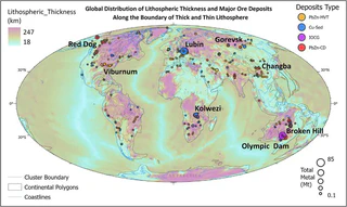
Cratons are the ancient, stable cores of continents that have remained largely unchanged for billions of years. The edges of these cratons — where old, thick lithosphere meets younger, thinner crust — are prime locations for finding valuable mineral deposits. Faults and fractures along these boundaries act as pathways for hot, metal-rich fluids to travel upward from the deep Earth and deposit minerals like copper, gold, lead, and zinc.
This study uses a state-of-the-art seismic model called REVEAL, which maps how earthquake waves travel through the Earth at high resolution, to precisely locate craton boundaries around the world. By analysing the speed of seismic waves at depths of 150 to 200 kilometres, and applying machine learning to cluster the results, the researchers can map the edges of cratons with unprecedented detail.
The results show that about 85% of the total metal content in the targeted mineral deposit types lies within roughly 120 kilometres of the craton boundaries identified by this method. By focusing on just 16% of Earth’s continental area — the zones near craton edges — explorers could potentially find over 80% of known target deposits. This provides a powerful new tool for guiding mineral exploration toward the areas most likely to host critical metal deposits needed for the energy transition.


I am an ARC Industry Research Fellow in the School of Geography, Earth and Atmospheric Sciences at The University of Melbourne. I am an expert in fusing Earth evolution models with data to understand how groundwater moves critical minerals through the landscape. Related research interests include the cycling of volatiles within the Earth, probabilistic thermal models of the lithosphere to unravel past tectonic and climatic events, and understanding the how enigmatic volcanoes form.
I am a vocal advocate for the integral role of geoscience in responding to challenges we face in transitioning to the carbon-neutral economy. As an expert in my field, I have been interviewed in national and international print media, TV, and radio on a wide variety of subjects including earthquakes, volcanoes, groundwater, and critical minerals.


