
Ray + Zarr: a better way to scale plate reconstruction workflows
Why I've moved from Dask to Ray for distributed raster processing, and why Zarr is the natural storage format to pair with it.
Why I've moved from Dask to Ray for distributed raster processing, and why Zarr is the natural storage format to pair with it.
GPlately version 2.0 has been released on GitHub — a major milestone for our open-source Python library for plate tectonic reconstructions. Here's a quick tour of what it can do.
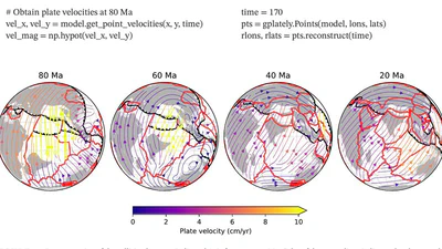
GPlately: a Python interface for deep-time spatio-temporal data analysis using pyGPlates, simplifying plate tectonic reconstructions.

The new Mac M1 processors are pretty cool, and are enough to convert this veteran Linux user to Mac. Since Mac M1, M2, etc. are all ARM-based there are some differences to be aware …
The new Mac M1 processors are pretty cool, and are enough to convert this veteran Linux user to Mac. Since Mac M1, M2, etc. are all ARM-based there are some differences to be aware …
A four-day workshop introducing participants to GPlates and pyGPlates for plate tectonic reconstructions and spatio-temporal data analysis. The course covers the GPlates desktop …
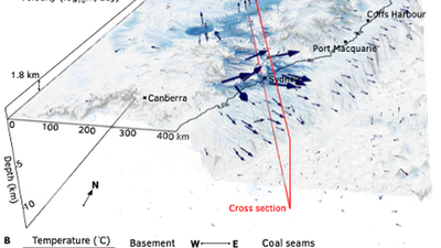
A scalable numerical framework for continental groundwater flow modelling, constrained by hydraulic head, recharge, and borehole temperature data using Bayesian inversion.
A Python package for computing Curie depth from magnetic anomaly data using Bayesian inference to probe the thermal structure of the Earth's crust.
Geodynamicists from Sydney and Australian National universities have developed Stripy, a software module that allows scientists to efficiently place GIS ‘wrapping paper’ around the …

Geodynamicists from Sydney and Australian National universities have developed Stripy, a software module that allows scientists to efficiently place GIS ‘wrapping paper’ around the …